Plate Tectonics
Plate Tectonics
Plate tectonics: The term was first coined by JT Wilson in 1965.
After the evolution of the concept of the “continental drift hypothesis” and “seafloor spreading” a broader concept of “plate tectonics” was developed in 1967. The theory of Plate Tectonics was introduced independently by McKenzie, Parker, Morgan, and Holmes in 1967.
Theory of Plate Tectonics
Plate tectonic theory states that the dynamics of the earth’s outer shell, the lithosphere are separated into plates that move over the asthenosphere, the upper molten portion of the mantle. Oceanic and continental plates come together, spread apart, and interact at boundaries all over the planet
- The Plate Tectonic theory was accepted after seafloor spreading was validated around 1960.
- The earth’s crust/lithosphere is divided into seven major and many minor rigid, continental, and oceanic tectonic plates. These plates are constantly moving.
- The Pacific plate is the largest oceanic plate while the Eurasian plate is the largest continental plate.
Name of seven major plates:
- Pacific plate: It is the largest plate that covers 1/5th of Earth’s surface.
- North American Plate
- The Eurasian and adjacent oceanic plate
- African Plate
- Antarctic Plate
- Indo-Australian plate
- South American Plate
Some Minor Plates:
- Nazca plate- Between South America and the Pacific plate
- Cocos plate- Between Central America and the Pacific plate
- Philippine Plate- Between the Asiatic and Pacific plate
- Caroline plate- Between the Philippine and Indian Plate.
- Philippine plate- Between the Asiatic and Pacific plate
- Fuji plate- Northeast of Australia.
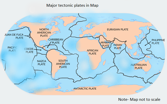
Major and minor plates of the world
Movement of Plates:
The tectonic plates are not in a fixed position as they move horizontally over the Asthenosphere. These plates collide, move apart, or slide next to each other which leads to earthquakes or volcanic eruptions.
Rate of Movement of tectonic plates: The rates of plate movement are determined with the help of the strip of the normal reverse magnetic field that is parallel to the mid-oceanic ridges.
The rates vary as follows:
- Slowest rate (less than 2.5 cm/yr.) – The Arctic Ridge’s
- fastest rate (more than 15 cm/yr.)- East Pacific Rise- (mid-oceanic ridge, a divergent tectonic plate boundary)
Forces responsible for the movement of tectonic plates:
- The tectonic plates are able to move due to the relative density of the oceanic lithosphere and the relative weakness of the asthenosphere.
- Dissipation of heat from the mantle is acknowledged to be the original source of the energy required to drive plate tectonics through convection or large-scale upwelling and doming.
- The excess density of the oceanic lithosphere sinking in subduction zones is a powerful source to generate plate motion.
- The weakness of the asthenosphere is also responsible for the easy movement of tectonic plates.
- Although subduction is thought to be the strongest force driving plate motions.
- These deriving forces are of three categories: mantle dynamics related, gravity related (main driving force accepted nowadays), and earth rotation related.
Plate Boundaries:
Plate boundaries are the area between the plates where most tectonic activities take place. Three types of boundaries exist and a fourth i.e. mixed type is characterized. Each type of plate boundary generates distinct geologic processes and landforms.
- Convergent Boundaries or destructive- Subduction
- Divergent Boundaries (Constructive)
- Transform boundaries (Conservative)
- Plate boundary zones
Convergent Boundaries (Destructive or active margins)- Subduction:
At convergent boundaries, the plates move and collide with each other. The collision buckles the edge of one or both plates, creating a mountain range or subduction of one of the plates under the other, creating a deep seafloor trench.
In simple words, it can be defined as “when two plates collide with each other, the denser one is subducted below the lighter one. The region where the subduction takes place is called the Benioff zone“.
The three different zones in convergent plate boundaries:
At the Zone of Ocean to Continent subduction: the dense oceanic lithosphere plunges beneath the less dense continent. example: The Andes mountain range in South America, and the Cascade Mountains in the Western United States.
- It leads to volcanism.
- Volcanoes are formed in the Benioff zone due to the accumulation and upwelling of excessive magma, which comes out breaking the weak part of the crust. e.g., the western side of the American plate, where the Pacific plate is subducted below the American plate, is the zone of volcanos.
At the Zone of Ocean to Ocean subduction: the older, cooler, denser crust slips beneath the less dense crust. Example: the Aleutian Islands, Mariana Islands, and the Japanese island arc
- The earthquake caused by this motion, deep trench form an arch shape.
- The upper mantle of the subducted plate then heats and magma rises to form curving chains of volcanic islands.
- Deep marine trenches are typically associated with subduction zones, and the basins that develop along the active boundary are often called “foreland basins”.
Continent to Continent: Collision between masses of granite continental lithosphere subduction. For example- the Alps were formed when the African plate collided with the Eurasian plate. The Himalayas, are also an example of continent-to-continent boundaries.
Divergent Boundaries or constructive:
At divergent boundaries, the plates slide apart from each other forming a narrow rift valley. These are constructive in nature. Here, geysers spurt super-heated water, and magma, or molten rock, rises from the mantle and solidifies into basalt, forming a new crust, and Oceanic ridges are constructed due to these plates.
- At the zone of the ocean to ocean rifting: divergent boundaries form by seafloor spreading, the formation of a new ocean basin.
- At the zone of the continent-to-continent rifting: Divergent boundaries cause new ocean basins to form continental split and spread. Example- Africa’s East African rift and the valley of the rift sea.
- Active zones of the mid-oceanic ridge– Example- The Mid-Atlantic ridge produces geysers and volcanos, and East Pacific rise.
- The Eyjafjoell volcano of Iceland erupted on 17.4.2010 on the divergent plate of the Atlantic Ocean.
Transform boundaries (conservative- Shearing or neutral plate margins): The transform boundaries occur where two lithospheric plates slide past each other along transform faults, they neither construct nor destroy. The transform faults occur across a spreading center.
- In this type of fault, strong earthquakes can occur.
- Example of a transform boundary- The San Andreas Fault in California.
Plate boundary zone: It occurs where the effects of the interactions are unclear, and the boundaries, usually occurring along a broad belt, are not well defined and may show various types of movements in different episodes.

subducting-plate
Movement of Indian Plate
The Indian plate includes Peninsular India and Australian continental portions. The subduction zone along the Himalayas forms the northern plate boundary in the form of continents – continent convergence.
In the east, it extends through the Rakiyoma mountains of Myanmar towards the Island arc along the Java Trench.
The eastern margin is a spreading site lying to the east of Australia in the form of an oceanic ridge in the southwest Pacific.
The western margin follows the Kirthar Mountains of Pakistan which further extend along the Markana coast and joins the spreading site of the Red Sea rift southeastward along the Chagos Archipelago.
The boundary between India and the Antarctic plate is marked by an oceanic ridge running in roughly the West-east direction and merging into the spreading site, a little south of New Zealand.
Post position of India
India was a large island situated off the Australian coast in a vast ocean. It was separated by the Tethys Sea from the Asian continent till about 225 million years ago.
- It was supposed that India started its northward journey about 200 million years ago at the time of the breaking of Pangea.
- India collided with Asia about 40 to 50 million years ago causing rapid uplift of the Himalayas.
- About 140 million years before the present, the subcontinent was located at 50° S latitude. The two major plates were separated by the Tethys Sea and the Tibetan block was closer to the Asiatic landmass.
- The outpouring of lava and formation of the Deccan traps started around 60 million years ago.
- The formation of the Himalayas took place 40 million years ago and thereafter, and it is believed that the process is still continuing at the height of the Himalayas is still rising.
You can also read:
- Volcano
- Continental Drift Theory
- The Rocks- Igneous Rocks
- Sedimentary rocks
- Metamorphic rocks
- Earthquakes
References:
Thank You 🙂

2 Comments
Earthquakes- definition, related facts - PCSSTUDIES - Geography · December 22, 2021 at 6:59 pm
[…] Plate Tectonic Theory […]
Location and Geological Divisions of India - PCSSTUDIES Geography · November 13, 2022 at 9:37 pm
[…] origin of these mountains is tectonic movements. These are dissected by young rivers (Fast-flowing rivers in nature also called youth […]