Earthquakes- definition, related facts
Earthquakes (also called quakes, tremors, or temblors)
A sudden movement of Earth’s crust is caused by the release of stress accumulated along geologic faults or by volcanic activity. In simple words, the earthquake refers to the shaking of the earth. Mainly it is a natural event caused due to release of energy and generates waves that travel in all directions.
We can say that an earthquake is a series of shocks and tremors resulting from the sudden release of pressure along active faults and in areas of volcanic activity.
Important facts related to earthquake
- Earthquake describes any seismic event which can be natural or caused by human activities. The earthquakes are mostly the result of geological faults, also caused by volcanic activity, landslides, mine blasts, and nuclear tests.
- The earthquake shows various ranges. The earthquakes cause tsunami, landslides, and sometimes volcanic activities also.
- Around 507,150 earthquakes are recorded annually, out of them, 50,000 are felt and one leads to destruction.
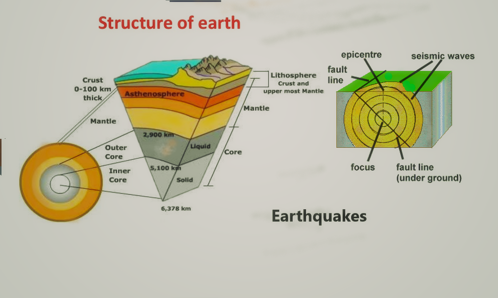
Structure of Earth and features related to Earthquake
Terms related to earthquake
- Magnitude: Magnitude is used to describe the size of the Earthquake. There are a number of different ways to calculate the magnitude of an earthquake, including the Richter Scale. Scientists also use the moment magnitude scale, which calculates the magnitude of an earthquake based on physical properties such as the area of movement (slip) along the fault plane
- Richter scale: The earthquake magnitude is estimated by the Richter scale. It was first developed by Charles F. Richter in 1935.
- Mercalli Intensity Scale: Intensity of damage and effect of an earthquake measured by it. The lower numbers show the intensity and the higher number indicates damage to structures and buildings.
- Seismograph: With this instrument, the record of seismic waves that are caused by earthquakes, explosions, or other earth-shaking phenomena is made.
- Hypocentre: (focus) it is the point of origin of an earthquake.
- Epicenter: The point on the earth’s surface directly above the hypocentre or focus.
- Measurement of Earthquake: The seismic waves travel through the earth’s interior and they can be recorded at a great distance with the help of seismometers. The moment magnitude scale measures the amplitude of shock and takes into account the seismic moment.
- Wave: The waves of earthquakes travel through and on top of the surface of the Earth causing shaking and vibrations on the ground. Earthquake waves can travel hundreds of kilometers causing earthquakes to be felt a long way away from the origin
Types of Seismic Waves:
Seismic waves are of the following types:
- Longitudinal P-waves (shock- or pressure waves)
- Transverse S-waves (both body waves)
- Surface waves – (Rayleigh and Love waves)
Propagation of Earthquake waves
P – Waves vibrate parallel to the direction of the waves. This exerts pressure on the materials in the direction of the propagation due to this, it creates density differences in the material leading to stretching and squeezing of the material.
In the interior of Earth, The P-waves travel much faster than the S-waves the approx. the relation is 1.7:1. The differences in travel time from the epicenter to the observatory are a measure of the distance and can be used to image both sources of quakes and structures within the Earth. Also, the depth of the hypocentre can be computed roughly.
In the upper crust, P-waves travel in the range of 2–3 km per second (or lower) in soils and unconsolidated sediments, increasing to 3–6 km per second in solid rock. In the lower crust, they travel at about 6–7 km per second; the velocity increases within the deep mantle to about 13 km (8.1 mi) per second.
The velocity of S-waves ranges from 2–3 km per second in light sediments and 4–5 km per second in the Earth’s crust up to 7 km per second in the deep mantle. As a consequence, the first waves of a distant earthquake arrive at an observatory via the Earth’s mantle.
On average, the distance (kilometer) to the earthquake is the number of seconds between the P- and S-wave times eight.
The S wave (shakes surface) and later arriving surface waves cause most of the damage compared to P- waves.
The emergence of shadow zone
During the time of an earthquake, all places on the earth do not record the seismic waves (P and S waves). Such zones are referred to as shadow zones.
It is observed that the seismograph located at any distance within 105° from the epicenter record the arrival of both P and s waves, whereas beyond 145° from the epicenter, the seismograph record only the arrival of P waves not of S waves.
So, the zone between 105° and 145° from the epicenter was identified as the shadow zone for both types of earthquakes.
The shadow zone of P-waves appears as a band around the earth between 105° and 145° away from the epicenter.
The entire zone beyond 105° does not receive S waves, so the shadow zone of S waves is larger and it covers over 40% of the earth’s surface.
Main Causes for Earthquake
The main causes responsible for Earthquake are as follows:
- Plate tectonics
- Volcanic Eruption
- Folding and Faulting (Compressing and fracture of rock)
- Anthropogenic
Plate Tectonic: The crust of the earth is made up of seven major and several minor plates. The plates are fit closely together. Their position is not static, as they are constantly moving relative to each other. Most of the earthquakes occur along the boundaries of major and minor plates.
Volcanic Eruption: It is one of the main causes of earthquakes. During the time of the volcanic eruption, earthquakes frequently occur.
Folding and Faulting (compression and fracture of rocks): Earthquake is also caused by the folding of rocks due to compressional forces.
- The fault is the fractured surface in the earth’s crust along which rocks are broken and displaced.
- When the earth moves along the line of fracture, an earthquake occurs.
- We can define fault as; the fault is a planar fracture or discontinuity in a volume of rock across which there has been significant displacement as a result of rock-mass movements.
- The san Andreas fault of California led earthquake in Los Angles in 1906.
- The earthquake in Japan, on 11 March 201, was a result of the subduction of the Pacific plate at Japan Trench, and deeps to the west beneath the Eurasian plate.
- According to Italy’s institute of geophysics and volcanology, the earth’s axis has shifted by 25 cm due to the earthquake, and it led to the shortening of 24-hour-day by 1.8 microseconds.
Anthropogenic: Human actions like extraction of minerals, deep underground mining, blasting of rocks by dynamites for construction of roads, dams, and reservoirs, nuclear explosion, etc. lead occurrence of earthquakes of various intensity and magnitude.
- The Koyna earthquake, in 1967 in the Satara district of Maharashtra was due to koyna reservoir constructed, that was in 1962.
List of Some Major/Important Earthquakes of the World:
- Shensi, China- 1556
- Kolkata, India- 1737
- Northern Peru- 1970
- Iran- 1978
- Banda Aceh, Sumatra, Indonesia- 2004
- Tohoku, Japan – 2011
- Sikkim, India- 2011
Earthquake Zones in India: In India, most earthquakes occur in the Himalayan belt. The folded Himalayas is marked as an unstable region. The Indo-Gangetic Alluvial track and runn of kachchh are also on the list of highly vulnerable.
Earthquake Forecasting: Its prediction has not been possible to date. In record, The Chinese, on the basis of seismographic studies, made almost accurate predictions about the Haicheng (China) earthquake in 1975.
Impact of Earthquake on Human life
In history, earthquakes have done great damage to human beings. It has destroyed many constructions. The major repercussions of earthquakes are:
- Deformation of ground surface
- Tsunamis (The seismic sea- waves)
- Rise and collapse of ground surface
- Loss of human lives and livestock
- Damage and destruction of Buildings, constructions, dams, roads, etc.
- landslides, flash – floods, a devastating fire
- Change in water level inside the earth (underground water level)
- The earthquake Fukushima Daiichi plant in Japan, shifted Honshu Island by 2.4 meters.
You can also read:
- List of main volcanoes in the world
- Volcanoes- Definition, Types, & Facts
- List of Important Glaciers of Himalayan mountain
- Plate Tectonic Theory
Reference: https://en.wikipedia.org/wiki/Earthquake
Thank You 🙂

1 Comment
Plate Tectonics - PCSSTUDIES - Geography Plate Tectonics · June 15, 2021 at 7:27 pm
[…] Earthquakes […]