The Ganga River System
The Ganga River system
The Ganga River is a trans boundary river of Asia that flows through India and Bangladesh. In Bangladesh, it is known as the river Padma.
The Ganga river system is the largest river system in India having an area of 8.6 lakh sq km consisting of perennial and non-perennial rivers which originate in the Himalayas in the North and the Indian Peninsula in the South.
Origin of Ganga: River Ganga rises in the Gangotri glacier near Gaumukh (3900m) in the Uttarkashi district of Uttarakhand. At the place of origin, the river is known as Bhagirathi, after joining Alakhnanda at Devprayag, it is known as Ganga.
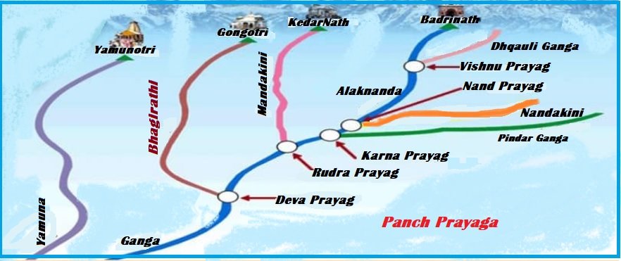
Five Prayags (Panch Prayag):
Prayag means the ‘Place of the confluence of a river’. The source of Alakhnanda is in the Satopath glacier above Badrinath. The river Alakhnanda is joined by its tributaries and forms important pilgrimage sites Known as five Prayags (Panch Prayag).
The Panch Prayag are as follows:
- Vishnuprayag: Dhauliganga (Originates from Niti Pass) joins the Alaknanda near Joshimath on the Badrinath route. Dhauli Ganga originates from Niti Pass, after traveling a distance of 25 km from Vishnu Prayag.
- Nandprayag: Nandakini joins the Alaknanda. The Nanda Prayag is second prayag.
- Karnprayag: Pindar River joins the Alaknanda River
- Rudraprayag: River Mandakini joins the Alaknanda
- Devprayag: Bhagirathi joins the Alaknanda to form Ganga in the Garhwal division of the state Uttarakhand.
Panch Prayag
States and cities through which Ganga flows
Ganga cuts through the Central and Lesser Himalayas in narrow gorges, then Ganga enters the plains at Haridwar. The length of the river Ganga is 2,252km which drains the area of Uttarakhand (110 km), Uttar Pradesh (1,450 km), Bihar (445 km), and West Bengal (520 km).
Cities through which Ganga flows:
Along the way between Allahabad and Malda, West Bengal, the river Ganga passes the towns of Chunar, Mirzapur, Varanasi, Ghazipur, Ara, Patna, Chapra, Mokama, Munger, Sahibgani, Rajmahal, Bhagalpur, Ballia, Buxar, Simaria, Sultanganj, and Farakka.
- At Bhagalpur, the Ganga begins to flow south-southeast and at Farakka, it begins its attrition by branching away from its first distributary, the 408 km long Bhagirathi-Hooghly, which goes on goes on to become the Hooghly River.
- Before the border with Bangladesh, the Farakka Barrage controls the flow of the Ganga, It diverts some of the water into the feeder canal linked to the Hooghly.
- The Hooghly River is formed by the merger of the Bhagirathi River and Ajay River at Katwa.
- The Hooghly River empties into the Bay of Bengal near Sagar Island.
Discharge of River Ganga:
River Ganga flows toward the South, South-east, and East, after that it splits into two distributary named Bhagirathi and Padma. The river finally discharges into the Bay of Bengal near Sagar Island.
- After entering Bangladesh, the main branch of the Ganga River is known as the Padma, which is joined by the Jamuna River. Jamuna River is the largest distributary of Brahmaputra. The further Padma joins the Meghana River and empties into the Bay of Bengal. It forms a 1,430 by 3,000 km Bengal fan, the world’s largest submarine fan.
The Ganges delta/Ganges Brahmaputra delta:
The Ganga Delta is formed mainly by large sediment-laden flows of the Ganga and the Brahmaputra rivers. The Ganga Delta is World’s largest delta.
- The Ganges Delta is also known as the Sundarbans Delta or Bengal Delta, it is consisting of the area of Bangladesh and the Indian state of West Bengal. The Ganges Delta is the world’s largest river delta. It is one of the most fertile regions in the world.
- The Ganges delta has a shape of a triangle and is considered to be an “arcuate’ (arc-shaped) delta.

Ganga basin
Tributaries of The Ganga River
River Ganga consists of various tributaries:
- Left bank tributaries of Ganga: Ramganga, Garra, Gomati. Ghaghara, Gandak, Burhi Gandak, Koshi, Mahananda
- Right bank tributaries of Ganga: Yamuna, Tamsa, Karamnas, Sone, Punpun, Falgu, Kiul, Chandan, Ajoy, Damodar, Rupnanrayan.
Some tributaries of Ganga and their description is given below:
Tributaries |
Description |
| The Yamuna | The Yamuna is the westernmost and longest tributary of the Ganga.
|
| The Chambal | It rises near Mhow in the Malwa plateau of Madhya Pradesh and flows northward through a gorge upward of Kota in Rajasthan where Gandhi Sagar Dam has been constructed.
|
| The Gandak | Gandak River comprises two streams namely Kaligandak and Trisulganga.
|
| The Ghaghara | The Ghaghara River originates from the glacier of Mapchachungo.
|
| The Kosi | The mainstream of Kosi named Arun rises from North of Mt. Everest in Tibet.
|
| The Ramganga | The river rises in the Garhwal hills near Gairsain.
|
| The Sarda or Saryu | River Saryu rises in the Milan glacier in Nepal Himalayas where it is known as Goriganga.
Along the Indo-Nepal border, it joins the Ghaghra where it is known as Kali or Chauk. |
| The Mahananda | The river Mahananda rises in the Darjiling hills.
|
| Damodar River | It occupies the eastern margins of the Chhota Nagpur plateau and flows through a rift valley and joins the Hugli River.
|
| Son | The Son is the major right-bank tributary.
|
Importance of river Ganga:
The Ganga is the most important river in India. It has a significant role in India from the point of view of its basin as well as its cultural significance. River Ganga is considered the lifeline of India as it provides water to 40% population of India. The river plays an important role in agriculture because its Basin consists of fertile soil. In Indian culture, the river is worshiped as Mother Ganga in the Hindu religion.
Plans of Government for Ganga:
(Click here for detailed information on Namami Gange Program ↓)
Namani Gange Programme is an integrated conservation Mission, approved as a “Flagship Programme” by Union Government in June 2014.
You can also read:
- Namami Gange Programme
- Rivers of India and their main Tributaries
- The Indus (Sindhu) River System
- Soils of India
Thank you 🙂

6 Comments
Rivers of India and their main Tributaries - PCSSTUDIES - Geography · March 2, 2022 at 10:57 am
[…] Ganga […]
The Peninsular drainage system - PCSSTUDIES - Geography · March 13, 2022 at 2:13 pm
[…] The Ganga river system […]
The Brahmaputra river system - PCSSTUDIES Geography · March 21, 2022 at 10:21 am
[…] The Ganga river system […]
Namami Gange Programme - PCSSTUDIES % Current Affaires · June 14, 2022 at 1:31 pm
[…] The Ganga river system […]
States and Capitals in India - PCSSTUDIES Geography · April 21, 2023 at 12:07 pm
[…] Pradesh has more than 32 large and small rivers. Ganga, Yamuna, Saraswati, Sarayu, Betwa, and Ghaghara are of larger religious importance in […]
Suez Canal - PCSSTUDIES Geography · July 1, 2023 at 10:37 am
[…] Ganga river system […]